

URGENT - FIRE WEATHER MESSAGE
National Weather Service Houston/Galveston TX
258 PM CDT Thu Mar 13 2025

Due to the influx of drier air and windy conditions coming up
for Friday and Saturday, fire weather conditions are expected
to range from elevated to critical across portions of Southeast
Texas. Southwest winds around 15 to 20 mph alongside relative
humidity values in the 20 to 25 percent range on Friday will
lead to critical fire weather conditions across the Brazos
Valley and the Piney Woods. More widespread low relative
humidity values in the teens and 20s is expected on Saturday
alongside gusty westerly winds. This creates a more widespread
critical fire weather threat.

TXZ177-178-199-210>213-226-227-235>238-313-335>337-140400-
/O.NEW.KHGX.FW.A.0002.250315T1700Z-250316T0200Z/
Walker-San Jacinto-Montgomery-Colorado-Austin-Waller-
Inland Harris-Wharton-Fort Bend-Inland Jackson-Inland Matagorda-
Inland Brazoria-Inland Galveston-Coastal Harris-Coastal Jackson-
Coastal Matagorda-Coastal Brazoria-
258 PM CDT Thu Mar 13 2025

...FIRE WEATHER WATCH IN EFFECT FROM SATURDAY AFTERNOON THROUGH
SATURDAY EVENING FOR WIND AND LOW RELATIVE HUMIDITY FOR PORTIONS
OF SOUTHEAST TEXAS...

* WINDS...West 15 to 25 mph with gusts up to 30 mph.

* RELATIVE HUMIDITY...As low as 19 percent.

* TEMPERATURES...Up to 80.

* IMPACTS...Any wildfires that start could rapidly increase in
  size and intensity, and move quickly.

PRECAUTIONARY/PREPAREDNESS ACTIONS...

A Fire Weather Watch means that critical fire weather conditions
are forecast to occur. Listen for later forecasts and possible
Red Flag Warnings.
Related Posts
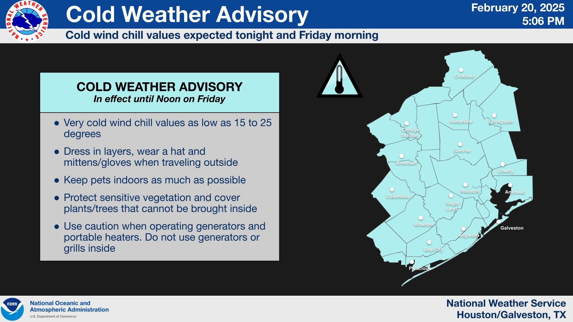
Cold Weather Advisory
Heads up, Southeast Texas…another chilly night ahead! A Cold Weather Advisory is in effect through Noon Friday. Bundle up when you leave in the morning, […]
National Weather Service officials say we will have a busy week!
https://www.facebook.com/share/v/18PtPmFGAg/?mibextid=wwXIfr