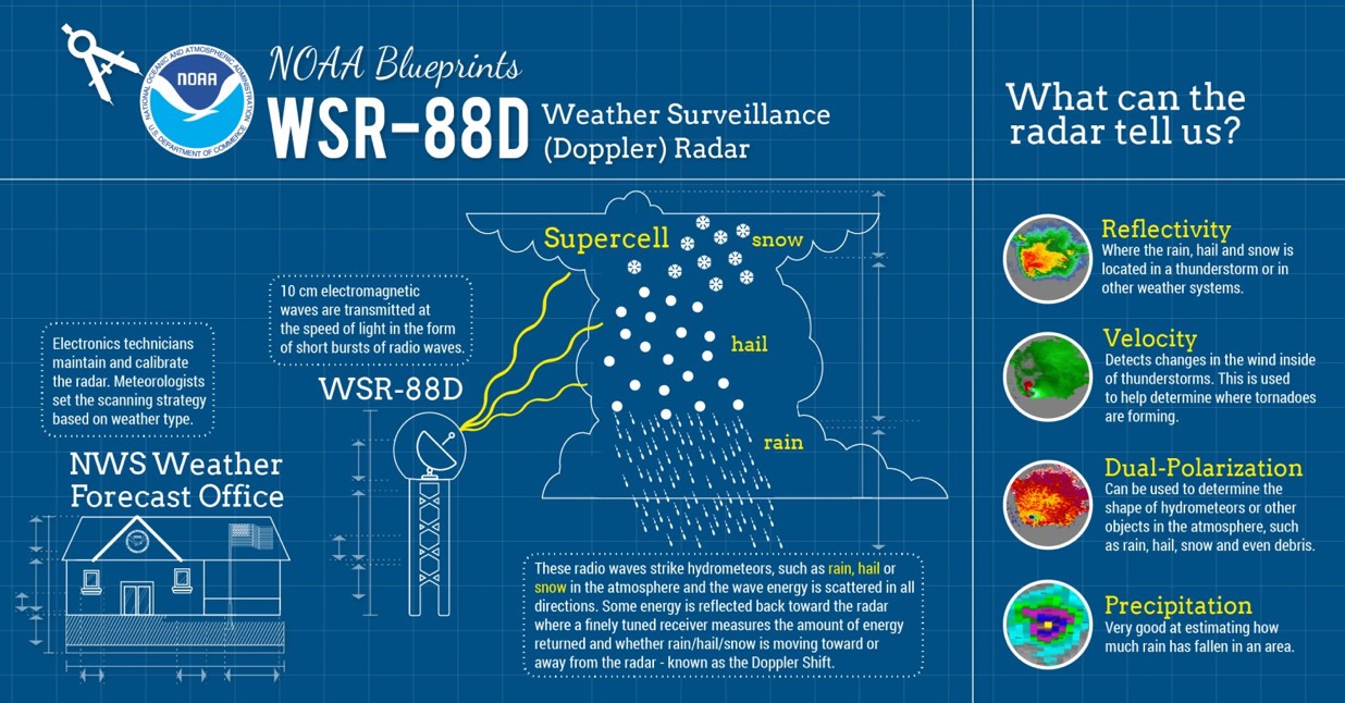

DENSE FOG ADVISORY IN EFFECT FROM MIDNIGHT TONIGHT TO 10 AM CST
TUESDAY…
URGENT – WEATHER MESSAGE
National Weather Service Houston/Galveston TX
232 PM CST Mon Feb 24 2025
Houston-Trinity-Madison-Walker-San Jacinto-Polk-Burleson-Brazos-
Washington-Grimes-Montgomery-Northern Liberty-Colorado-Austin-
Waller-Inland Harris-Chambers-Wharton-Fort Bend-Inland Jackson-
Inland Matagorda-Inland Brazoria-Inland Galveston-Southern
Liberty-Coastal Harris-Coastal Jackson-Coastal Matagorda-Coastal
Brazoria-Coastal Galveston-Matagorda Islands-Galveston Island-
Bolivar Peninsula-
Including the cities of Huntsville, Brenham, Liberty, Eagle Lake,
Baytown, El Campo, Bay City, Brookshire, Texas City, Missouri
City, Wharton, Caldwell, Groveton, Sugar Land, First Colony,
Prairie View, Trinity, Dayton, Coldspring, Clute, Sealy, Edna,
Mission Bend, Houston, Rosenberg, Winnie, Shepherd, Waller,
Corrigan, Devers, Weimar, Anahuac, Lake Jackson, Dickinson,
Cleveland, Bryan, Angleton, Mont Belvieu, Stowell, League City,
Freeport, Navasota, Columbus, Conroe, Palacios, Somerville,
College Station, Madisonville, Crockett, Alvin, Pasadena, La
Marque, The Woodlands, Ganado, Livingston, Pecan Grove,
Bellville, Friendswood, Pearland, Hempstead, Galveston, and Old
River-Winfree
232 PM CST Mon Feb 24 2025
…DENSE FOG ADVISORY IN EFFECT FROM MIDNIGHT TONIGHT TO 10 AM CST
TUESDAY…
- WHAT…Visibility one quarter mile or less in dense fog.
- WHERE…Portions of south central and southeast Texas.
- WHEN…From midnight tonight to 10 AM CST Tuesday.
- IMPACTS…Low visibility could make driving conditions hazardous.
- ADDITIONAL DETAILS…Dense fog may impact the morning commute for
Tuesday. Motorists should exercise caution if they encounter any
patches of dense fog, especially on busy and or congested roadways.
PRECAUTIONARY/PREPAREDNESS ACTIONS…
If driving, slow down, use your headlights, and leave plenty of
distance ahead of you.